
Ride a Pet Map: Locations and Landmarks
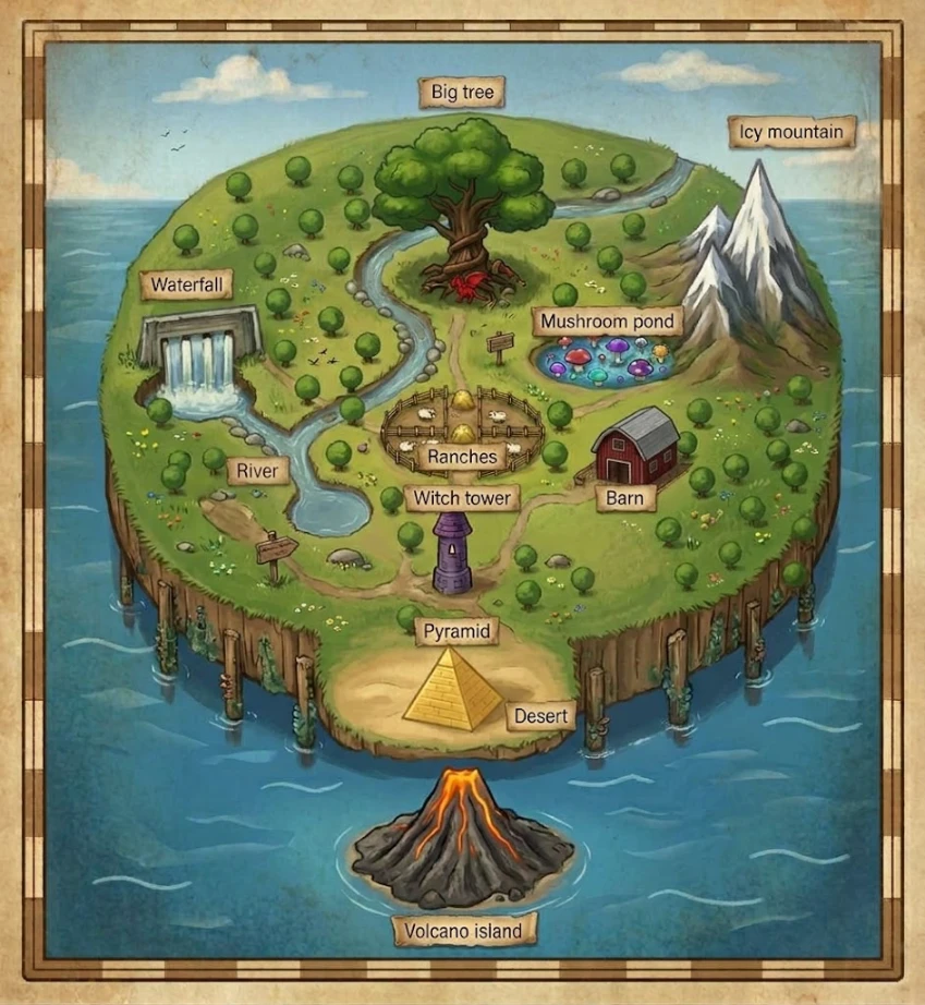
The Ride a Pet map shows a green island surrounded by blue water, with winding paths, a curving river, and clearly labeled landmarks. Snowy mountains rise on one side, a sandy desert sits at the bottom, and a separate volcanic island lies just offshore. This guide introduces the locations shown in the illustration and explains where to find them on the map.
Big Tree
The Big Tree stands near the top center of the island. Its broad green canopy, thick trunk, and exposed roots make it one of the map's most recognizable landmarks. A red plant sits at its base, while the river curves around the left side of the grassy hill.
Icy Mountain
The Icy Mountain occupies the upper-right side of the Ride a Pet map. Tall, pointed peaks rise above the nearby trees, with white snow covering their upper slopes. The rocky mountain base meets the green landscape beside Mushroom Pond.
Mushroom Pond
Just below the mountains and to the right of the Big Tree, Mushroom Pond adds a splash of color to the island. Red, purple, blue, and other brightly colored mushrooms cluster in and around the small blue pool. A nearby path leads toward the center of the map.
Waterfall and River
The Waterfall appears on the left side of the island, where water pours through a rectangular stone structure into a pool below. Its stream joins the River, which winds from the upper part of the island, past the Big Tree, and down the left side of the Ranches. Rounded stones line sections of the riverbank, and the water widens into a pool farther down the map.
Ranches
The Ranches sit near the center of the island. Wooden fences divide the rounded enclosure into smaller pens, with yellow hay piles visible inside. Paths connect this central landmark with the Big Tree above, the Barn to the right, and the Witch Tower below.
Barn
To the right of the Ranches stands the Barn, a red building with a gray roof and dark double doors. Trees and small rocks surround it, and a dirt path curves past its entrance toward the other central locations.
Witch Tower
The Witch Tower stands below the Ranches, near a junction in the island's paths. Its narrow purple walls and pointed roof distinguish it from the nearby Barn. On the map, it sits between the grassy central area and the sandy Desert farther down.
Desert and Pyramid
At the bottom edge of the main island, the green grass gives way to the Desert. A golden Pyramid stands in the middle of this sandy area, with its block-like stone pattern clearly drawn. The desert forms a small coastal extension bordered by cliffs and water.
Volcano Island
Volcano Island lies below the main island, separated from the Desert by a stretch of blue water. A dark rocky volcano dominates the small outcrop, with bright orange lava flowing from its glowing summit down the slopes. No bridge is shown between the two islands.
Finding Your Way Around the Ride a Pet Map
Use the central Ranches as a visual reference when reading the Ride a Pet map. The Big Tree is above them, the Barn is to their right, and the Witch Tower is below. The Waterfall and River mark the left side, while Icy Mountain and Mushroom Pond mark the upper-right area. At the bottom, the Desert and Pyramid point toward the separate Volcano Island offshore.